| |

About Social Bookmarking


|
Malhamdale Farm
Survey 1942
When the Second World War began, Britain was faced
with the need to increase home food production and the area of land
under cultivation had to be increased significantly. The Minister
of Agriculture and Fisheries set up County War Agricultural Executive
Committees (County War Ags) to oversee this increased food production.
They had powers to direct what was grown, to take possession of
land, to terminate tenancies, to inspect property, and to organise
mobile groups of farm workers. One of the first tasks was to direct
a ploughing-up campaign with large expanses of grassland being prepared
for cultivation and instructions given as to what should be planted.
To assist in this campaign, a preliminary farm survey was started
in June 1940 and farms were classified A, B, or C depending on
their productive state (ie. the physical condition of the land)
and the managerial efficiency (or otherwise) of the farmer (in extreme
cases land was taken over by the local Committee). The "War Ag" instructed
farmers to plough part of their land and plant alternative crops,
as can be seen in the extracts below.
Having reached their initial goals the Ministry of Agriculture
and Fisheries then started a 2nd survey to be used in forward planning,
which like Domesday would provide a "permanent and comprehensive
record of the conditions on the farms of England and Wales".
The National Farm Survey undertaken by district committees consisting
of experienced farmers, and was begun in early 1941 and completed
by the end of 1943. Every farm and holding of five acres or more
was surveyed in addition to the information already gathered in
a census return of farms completed by the farmers on June 4th 1941,
which had included crop acreage, livestock numbers, information
on rents and their length of occupancy.
The records created by the inspectors for each farm included information
on the conditions of tenure and occupation, and the general state
of the farm including its fertility, adequacy of equipment, water
and electricity supplies, weeds or pest infestations, and general
management, and a map showing the fields and boundaries for each farm
was also produced.
View the National Archives National
Farm Survey Leaflet  for further information.
Using the Farm Survey Information
The farm survey records for Malhamdale held at the National Archives, were photographed and the information transcribed into tables, making it easier to display and read. The tables for each farm are arranged by the Township the farm lies in, and links to all the farm details are on the relevant Township page.
This page offers three ways to access the data:
1. By Township - If known, this can be found by
selecting the relevant area on the Township map below. This will open a page for that township
where each individual farm is listed along with links to the survey data and relevant map.
Each township was given
a code and each farm a suffix number, for example Dykelands Farm (1), situated in the
township of Scosthrop (474) has a code 474-1, and the survey maps indicate
the fields belonging to a particular farm using that identification and a colour code.
2. By Location - The right hand Survey Areas locator shows the coverage of the individual survey maps and you can browse the actual map by selecting the area. (Note : the map windows can be resized.)
3. By Farm Name - To search for a known farm, at the bottom of the page you will find an Aphabetical List of Farms surveyed, with links to the relevant Township page where further details can be found.
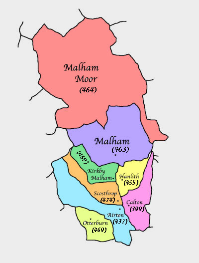
Township Map
Select the area to view the Township page and find
individual farm details.
|
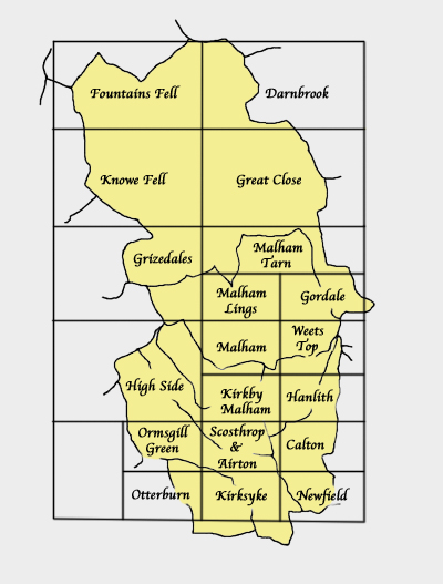
Survey Areas
Select an area to view the relevant survey map (re-sizeable) |
|
|
|
| Malham, Mallam, Malum, Maulm, Mawm, Malam, Mallum, Moor, Moore, More, Kirkby, Kirby, Mallamdale, Mallumdale, Malhamdale, Malham-Dale, Kirkby-in-Malham-Dale, Kirkby-Malham-Dale, Kirby-in-Malham-Dale, Kirby-Malham-Dale, Hanlith, Hanlyth, Scosthrop, Scosthorpe, Skosthrop, Airton, Ayrton, Airtown, Calton, Carlton, Craven, Yorkshire, Otterburn, Otter Burn, Bellbusk, Bell Busk, Conistone, Family, Genealogy, Geneology, Buildings, People, Maps, Census, Scawthorpe, Scothorpe, |

Cold, Coniston Cold, Bordley, Bordly, Boardly, Boardley, Winterburn, Winter Burn, History, Local, ancestors, ancestry, Scorthorp, Wills, Tax, Eshton, Asheton |
KirkbyMalham.info is not responsible for the content of external internet sites. External links are generally indicated by the symbol.
|
|
|
