| |

About Social Bookmarking


|
|
Middle House

The house stands on what was probably a Norse settlement,
later taken over as a grange by Fountains Abbey and is situated at the
junction of the old roads from Darnbrook and Arncliffe. The house is
recorded as Midlow House as early as the 14th century in monastic documents. In the Poll Tax Rolls of 1379 for Malhamdale you can find Adam de Medlehewe in Malham, and in Otterburn Johannes de Medylhowe, plus others with similar surnames indicating thier origin in Threshfield and Coniston in Wharfedale. In 1480 John Brown was a shepherd here for Fountains Abbey, keeping
275 wethers and 30 hoggs.
Here in the valuation of the Fountains Abbey estates made at the time
of the Dissolution of the Monasteries in 1546, we see:
Midlow House - Parcell of the same Manor of Malham and of the same
parish ...Richard Brown holdeth a tenemnt ther, with lands etc. thereunto
belonging, and rentieth by the yere, at Martyn and Pentecost ....................xxs
(rent 20 shillings pa)
Item:
ther is a pastor for shepe at the saide Midlowhouse, and is worth
by the yere .................................................................................xxvjs
viiijd (26s 8d pa)
At the Dissolution most of the Malham Moor property was purchased by
Sir Richard Gresham and in the course of the next century many properties
were sold to their occupants or let on long leases. Thomas Lister of
Gisburn Park (later Lord Ribblesdale) purchased the majority of Malham
Moor in the eighteenth century and this then passed to the Morrison
estate in the 19th century. Thomas Lister had also commissioned a survey
of his original holdings in West Malham & Malham Moors in 1760 and
another of the Lambert lands he had acquired in Malham Moors and East
Malham in 1785/6. Middle House doesn't appear in the detailed schedule
for the land owned by Lister in 1760, however there is a full description
of it in the 1785 estate survey which covers the land he had recently
acquired from the Lamberts of Calton, although no tenant's name is given
and it described as "in hand". Penciled notes in the back
of the schedule book indicate that the estate was being added to at
the time and various plots were being exchanged with other landholders.
Thomas
Lister's Estate Survey - 1785
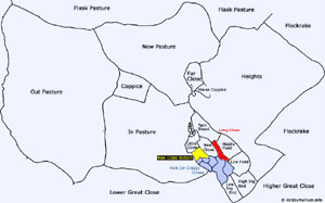
| Middle-House Farm |
Acres
|
Roods
|
Perches
|
| House, Outhouses, Gardens, Courts, Yards Etc. |
-
|
1
|
37
|
| Little Close |
1
|
2
|
09
|
| Tarn Stead |
3
|
1
|
09
|
| New Close |
2
|
-
|
02
|
| New Close Bottom |
1
|
-
|
08
|
| Helk ( or Cragg) Closes - 6a |
-
|
1
|
01
|
| Helk ( or Cragg) Closes - 6b |
-
|
-
|
36
|
| Helk ( or Cragg) Closes - 6c |
-
|
2
|
17
|
| Helk ( or Cragg) Closes - 6d |
-
|
2
|
17
|
| Helk ( or Cragg) Closes - 6e |
1
|
3
|
21
|
| Helk ( or Cragg) Closes - 6f |
-
|
3
|
18
|
| Low Ing End, with a Barn & Cowhouse |
2
|
1
|
03
|
| High Ing End |
3
|
-
|
35
|
| Low Field, with a Barn & Cowhouse |
2
|
3
|
02
|
| Middle Field |
2
|
3
|
23
|
| Long Close |
-
|
2
|
04
|
| Height |
83
|
3
|
10
|
| Horse Coppice |
-
|
3
|
23
|
| Far Close, with a Barn, Cowhouse, Yd, & Parrock |
3
|
-
|
08
|
| New Pasture |
54
|
-
|
-
|
| In Pasture |
54
|
2
|
38
|
| Coppice taken out of Do. |
5
|
3
|
30
|
| Out Pasture |
114
|
-
|
20
|
| NB. Right on Flockrakes Described by Meer Stones |
|
|
|
|
Total
|
341
|
-
|
11
|
Although ownership may have changed, physical changes to Malham Moor
since the end of the monastic period have been relatively small and
include some further land enclosure, tree planting/cutting and the general
replacement of buildings. The early estate map clearly shows 18th century
Middle House as an isolated, but compact holding, typical of monastic
upland vaccaries or stock farms and very reminiscent of Sawley Abbey's
similar holding at Stockdale. All the Malham Moor farmsteads dating
from the monastic period remained well into the 19th century and Middle
House with its fascinating collection of small stock management enclosures
has changed very little except for the addition of the new farmhouse
and buildings at the head of Great Close.
The general opinion is that prior to the 17th century
most of the buildings in Malhamdale would have been of single storey
cruck built construction, using pairs of curved timbers to create an
A frame supporting the roof independently of the walls. These would
probably have had low stone walls under a ling or straw thatched roof.
These earlier buildings were upgraded or replaced from about 1600 onwards,
with buildings of all stone construction, with the dwellings rebuilt
mainly as two storey houses, with stone slate roofs. However the picture
is probably not as simple as that, as just as we do today,. buildings
were often modified and extended to suit the owners requirements and
the fashions of the time.
Some local buildings show evidence of their alteration from earlier,
possibly cruck buildings, with older foundations and large pad stones
for the crook beams remaining in the base of the building, gables showing
the older steeper pitch required for the thatch where the stonework
has been extended leaving a "shadow", and walls showing clear
evidence of being raised above the original single storey height. Materials
from the old building would be reused and timbers from cruck built buildings
are often seen in the roofing timbers of later rebuilds, identifiable
by the style of the old, now unused joints they still show.
Middle house has been much modified, and Raistrick thought
it dated from the late 16th century, built on an earlier site. It's
most obvious early features date from the 17th century when the farm
was tenanted or possibly owned by the Knowles family. They had farmed
on Malham Moor for many years and the will of William Knoll of Mallome
More who died in 1539 asks:
' to be buried in the Church of Sancte Michaell Archangell, of Kirkbie
in Mallough-dale as ner Sancte Sonday as the ground will serve.'
The building was Grade 2 listed in 1989 and has been consolidated and
restored since then by the National Trust. It had long been redundant
and the census doesn't show anyone living there after John Swinbank
in 1881, whose father, William Swinbank was at new Middle House farming
the 1500 acres. It was used as additional housing associated with "New"
Middle House up to the beginning of the 20th century when it came into
agricultural use.

Middle House in the 1930s, the steps were later dismantled and a
large doorway made
for agricultural access. This was recorded by Arthur Raistrick in his
1976 book.
Now consisting of three rooms, two from the first phase
of building and another added later, the remains of the bay on the right
was possibly housing for animals. In the original plan, the door had
opened into an unheated room, possibly a byre, indicating a building
with a typical hearth-passage plan. The porch was thought by Morkill
(repeated by Raistrick) to have been added by Henry King in 1721 (see
note below) and the rather crude porch certainly could be 18th century.
It formed a new entrance into the living room-kitchen. The narrower
inner room was probably divided into an unheated bedroom and larder.
The left bay was thought to have been added in the mid-late C18, ,possibly
at the same time as the porch and, and has a curved recess which may
have been a built-in cupboard. The 1785 estate map shows the building
divided in two, with what appear to be individual garden plots in front
of them, so this addition could have been made so that it could be split,
rather than as an addition to the existing accommodation.
 |
The HK on the lintel at Middle House is unlikely to refer to the
Henry King which both John W Morkill and later, Arthur Raistrick
surmised in their publications. There is no evidence for the King
family having connection with Malham Moor or the building. The date
of 1721 that they attributed to the building of the porch came from
the fact that Henry King (or perhaps that was Knowles too?) had
the same initials on a pew in the church of that date, rather scant
evidence. Much more likely is that HK was one of the Knowles family
who farmed Middle House for many years (see Knowles
of Middle House wills). The lintel is not 18th century, more
likely 17th century and reused from elsewhere. The 17th century
was the period when initials and dates on lintels were popular in
the area and this well carved and chamfered, slightly curved lintel
sits awkwardly on the crude 18th century porch with its square jambs.
The Parish Records of Kirkby Malham church hold a very likely entry
for an original builder with the initials HK living in the period
when the house was remodeled and the lintel carved:
Henry Knowles late of Middlehouse Sepult (buried) 10th day of
May 1666
Henry's son Martin continued to farm there until his death, and the Knowles wills show the family was still there in 1734. |
A fine range of 17th century barns stands just to the
south of the house, but just as interesting, are the ruins of a 2 bay
building, which may well be an earlier house or barn, extending from
the north corner of the remaining building.
The new Middle House farm buildings were erected a little further south
overlooking Great Close, by Walter Morrison in his typical estate style
during the second half of the 19th century.
|

View showing the remains of the buildings to the north of Old
Middle House.
|
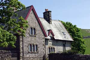 The new Middle House farm built in Walter Morrison's typical
"estate style". This can be seen in numerous places around
Malhamdale, including The Buck Inn and Kirkby Malham Church Hall,
as well as on the estate farms.
The new Middle House farm built in Walter Morrison's typical
"estate style". This can be seen in numerous places around
Malhamdale, including The Buck Inn and Kirkby Malham Church Hall,
as well as on the estate farms. |
 Details
of the Old Middle House buildings
Details
of the Old Middle House buildings
These details have been edited from the listed building entry, the
original version of which is available online at the English Heritage
website - Images of England
 and refer to the survey carried out sometime before the building was
restored by the National Trust. In the description, the bays are described
as numbering 1-5 from left to right as you view the front of the building,
although only the first three remain. Their 4th and 5th bays appear
to refer to the building which once had the outside staircase, it
only appears to be a single bay in the old photographs, but the east
end of the building had collapsed by the time this survey was made
in the 1980s. The building as it stood before the collapse of the
east end can be seen in the post war photograph by Arthur Raistrick
which can be found in his book "Buildings of the Yorkshire Dales". and refer to the survey carried out sometime before the building was
restored by the National Trust. In the description, the bays are described
as numbering 1-5 from left to right as you view the front of the building,
although only the first three remain. Their 4th and 5th bays appear
to refer to the building which once had the outside staircase, it
only appears to be a single bay in the old photographs, but the east
end of the building had collapsed by the time this survey was made
in the 1980s. The building as it stood before the collapse of the
east end can be seen in the post war photograph by Arthur Raistrick
which can be found in his book "Buildings of the Yorkshire Dales".
Farmhouse Description Farmhouse,
now derelict, built in the mid C17 with probably an early C18 porch
and alterations, converted to a farm building in the early 20th Century.
Constructed of limestone and gritstone rubble with quoins, plus an
ashlar block porch and with a graduated stone slate roof, it consists
of 2 storeys, with 3 bays standing and 2 (or 1) bays ruined at the
time of resurvey (1980s), the left-hand bay being an addition (Raistrick
also suggests the east end is a later addition). The ashlar single-storey
porch has chamfered lintel and recessed plaque with raised letters,
"H K ". (As previously noted, this appears to be reused.)
Front It has recessed chamfered
mullion windows throughout, with 4 and 2 lights to bays 1 and 2 on
the ground floor, with the far left mullions missing and the bay 2
mullions hollow-moulded. On the first floor there are three 2-light
windows, the central mullion lower and lacking the mullion. Hood moulds
are visible on windows to the left of and above porch. To right of
the porch there was a blocked window - the left and right jambs remaining
in this now ruined wall.
A break in the building line to first floor between bays 1 and 2 and
traces of a blocked doorway on the far left indicate that bay 1 is
additional to bays 2 and 3. There is a banded end chimney stack on
the far left. The roof of bays 3, 4 and 5, and the front and east
gable walls of bays 4 and 5 have collapsed apart from the blocked
original doorway between bays 4 and 5, which has chamfered quoined
jambs and a triangular arched head under a square chamfer.
Rear At the rear the walling survives
to full height. There is a blocked central doorway (opposite the porch
entrance) and all other openings also blocked. There is a 2-light
recessed chamfered mullion window to the right, and a similar single
light above and with another single light to left. There are also
the remains of an external staircase and loading door between the
rear door and right-hand window, and a straight join between the right
bay (1) and rest of the building.
Interior In bay 1 there is a
gable fireplace with plain stone surround, a shallow curved recess
and blocked 2- light window in the partition wall between bays 1 and
2. The standing partition wall between bays 4 and 5 has a stone stack
under built in brick. Measured drawings made in 1986 show a large
inserted window to right of the porch (?C18) and a 19th Century/20
east entrance to right of the original doorway.
The rear stairs and first-floor doorway indicate the conversion of
the house to agricultural use in the 19th Century/20, when louvres
were inserted into several of the front windows and the cart entrance
opened up on the front.
Stable with pigeon loft over
Also listed is this associated building standing just a few yards
away.
The stable and pigeon loft is probably an early C18 construction reusing
C17 remains. Constructed of gritstone rubble with quoins and a graduated
stone slate roof it consists of 2 storeys, with a single cell.
South wall This has a board door,
in quoined surround with large lintel and a square louvred opening
to left.
East gable On the first floor
is a blocked 2-light, recessed chamfered mullion window, the mullion
missing. There are 4 tiers of pigeon holes arranged in a pyramid with
1,2,4 and 6 holes, with perching stones to gable. There is a row of
through stones at the first-floor level.
North front With a square forking
hole below the eaves, quoined jambs and random through-stones to this
wall.

Middle House was still occupied when it was painted
by John Ruskin (1819-1900) on one of his visits to Walter Morrison.
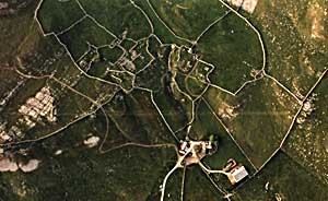
Aerial photograph Middle House using FlashEarth.com. A user friendly aerial photograph viewer, but it needs a broadband connection.
|
| Malham, Mallam, Malum, Maulm, Mawm, Malam, Mallum, Moor, Moore, More, Kirkby, Kirby, Mallamdale, Mallumdale, Malhamdale, Malham-Dale, Kirkby-in-Malham-Dale, Kirkby-Malham-Dale, Kirby-in-Malham-Dale, Kirby-Malham-Dale, Hanlith, Hanlyth, Scosthrop, Scosthorpe, Skosthrop, Airton, Ayrton, Airtown, Calton, Carlton, Craven, Yorkshire, Otterburn, Otter Burn, Bellbusk, Bell Busk, Conistone, Family, Genealogy, Geneology, Buildings, People, Maps, Census, Scawthorpe, Scothorpe, |

Cold, Coniston Cold, Bordley, Bordly, Boardly, Boardley, Winterburn, Winter Burn, History, Local, ancestors, ancestry, Scorthorp, Wills, Tax, Eshton, Asheton |
KirkbyMalham.info is not responsible for the content of external internet sites. External links are generally indicated by the symbol.
|
|
|
